Difficulty: Moderate with some short climbs and rocky slopes, 4.5 miles round trip.
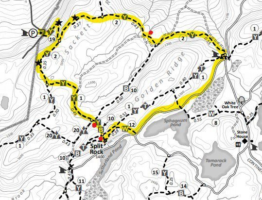
Parking: Mine Hill Parking Area, Black Rock Forest. Near the top of Mine Hill Road, Cornwall NY (Black Rock Forest-Northern Loop Trailhead on Google Maps) Parking for 5-6 cars, no roadside parking.
Points of Interest: The Beattie Cabin, Quarry, Golden Rock, Split Rock and Sackett Ridge
The Beaty Cabin Narrative: John Brady, BRF Forest Historian
Trail Narrative: Aaron Culotta, BRF Environmental Educator
NOTE: This trail narrative is a historical guide to highlights of the western side of Black Rock Forest and is a moderately challenging hike. Supplement the above map insert with our full trail map and note the shapes and colors of trail blazes. (especially on the yellow trails)
Sackett Secrets from the Mine Hill Trails
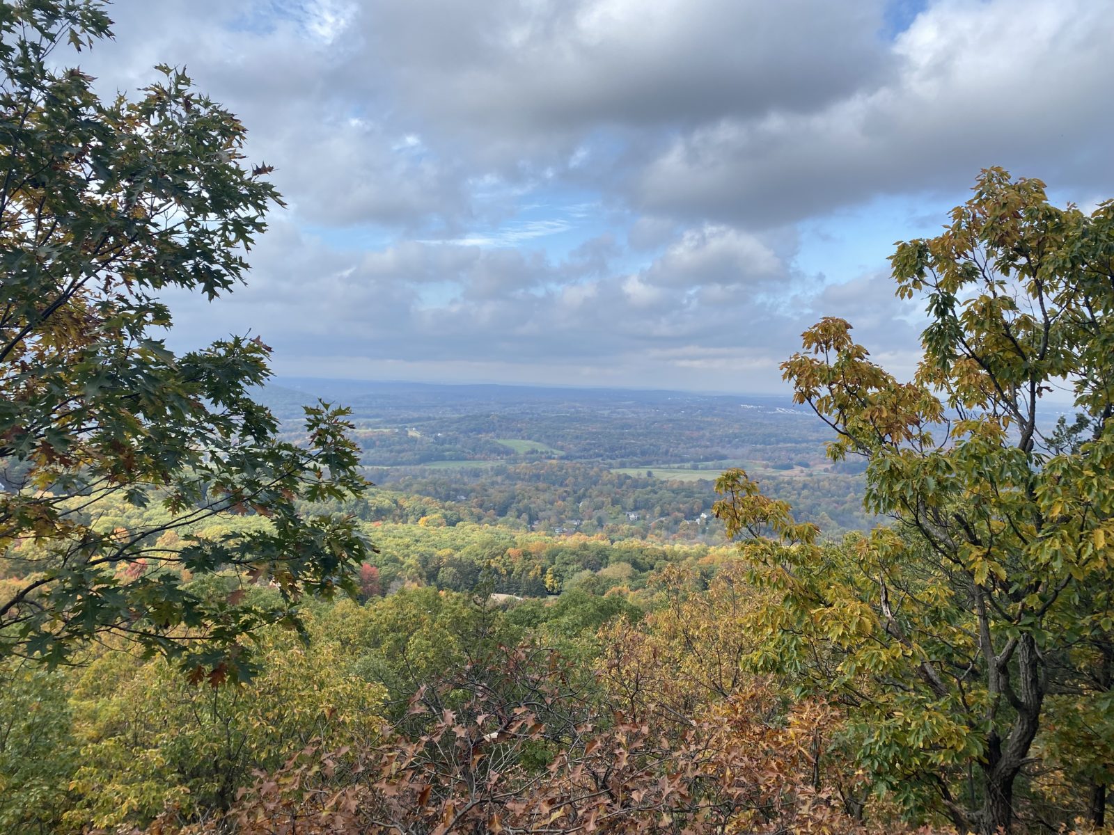
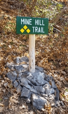
Enter the start of the yellow/diamond blazed Mine Hill Trail located just uphill, and across from the parking area (trail entrance, photo right). The first quarter mile of this hike will be steep but the view spots above are rewarding – enjoy looking to the West, at Schunnemunk Mountain, the Shawangunks, and Catskill Mountains.
After climbing roughly 250 ft of elevation, you will have reached the end of the Mine Hill Trail. Make a left and head north on the yellow/circle blazed Sackett Trail for roughly 0.8 miles. While walking along this trail take note of the various understory species and layers of ground level flora. This part of the Forest has a relatively unique species and habitat composition compared to other parts of BRF. As you reach the end of this leg of the Sackett Trail, be sure to keep an eye out for the Beattie Cabin located on your left just past the two small stream crossings before Hall Road. Full description by Forest Historian, John Brady below!
THE BEATTIE CABIN HISTORY
Nestled between Sackett Ridge and Black Rock Mountain, you will come upon a remnant of this cabin – a stone chimney structure rising up on your left as the trail turns to the right. This highland ravine is historically approached by Hall Road off Continental Road above the Canterbury Brook and continuing to Sutherland Pond. The nearby natural pond was a popular camping spot for Dr. William Beattie and his five children as early as 1875.
Dr. Beattie (1826-1899), was a much-loved pioneer doctor of Cornwall. Many of his patients were poor, isolated Highland families located miles into the mountains of Black Rock Forest. Traveling by horse drawn wagon and sled, he would sometimes bring along one of his children. Often, it would be his daughter, Mary (1864-1963), a lover of nature and fearless rider of horses. Mary Beattie would marry Sidney Sherwood in 1891 and it was their five children that would enjoy this woodland cabin.
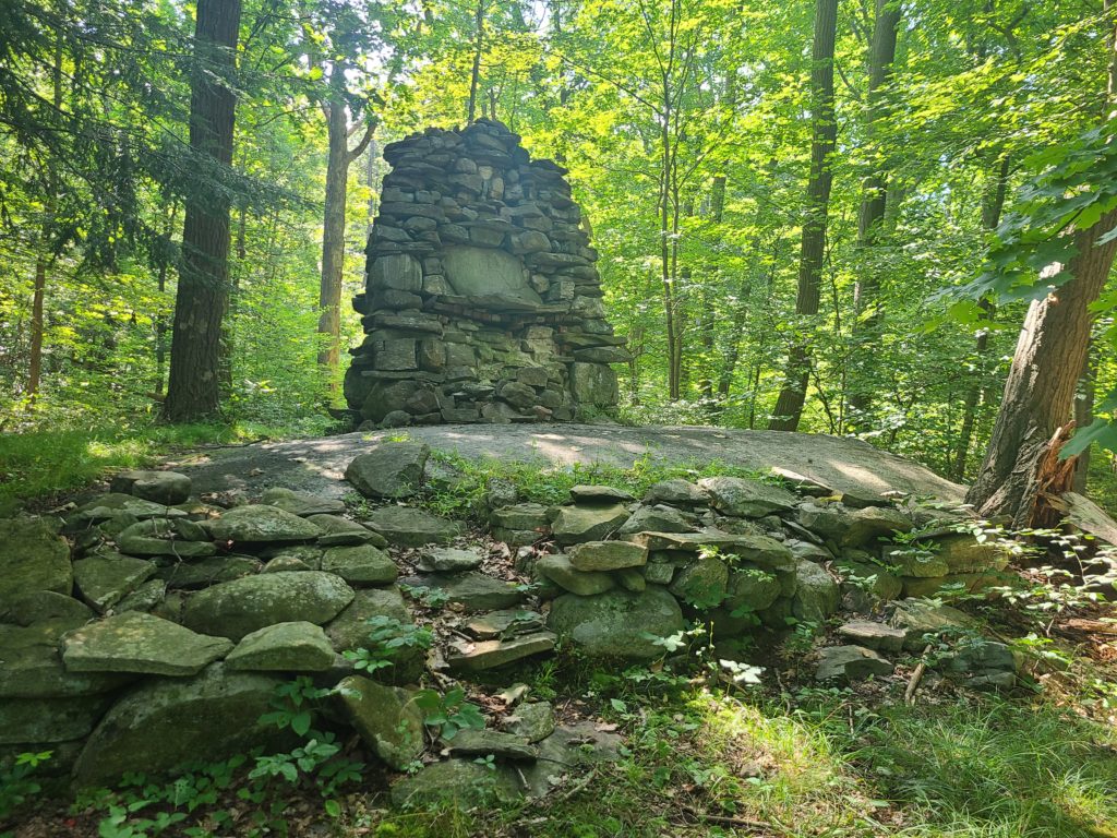
The cabin was built by Dr. Matthew Beattie (1860-1922), Mary’s brother. To support Mary’s children’s enthusiasm for nature, Uncle Matt then took on the challenge of this woodland cabin. The only remnant of the 120-year-old cabin is the conically shaped stone fireplace. The cabin once stood 20 ft tall and 10 ft in diameter, placed atop a huge boulder outcropping. The fireplace displays Uncle Matt’s signature decoration of fancy and unique stones above the mantle similar to his stone fireplace in the family’s log cabin on Angola Road.
A nearby stream, Beattie Brook, provides boulder bordered pools for natural bathing. This woodland camp is precisely located for naturalist delight, suiting the Beattie and Sherwood families. Mary Sherwood was the widowed mother of five exceptional, educated and successful children. She and her father were said to have touched the lives of every citizen of Cornwall and she became a friend and confidant of Eleanor Roosevelt. A wonderful source of information concerning the Beattie and Sherwood Families can be found in the book Making a Difference by Margaret Hodges.
After stopping by the Beattie Cabin…
Continue on the yellow/circle blazed trail towards Hall Road. After reaching this unmaintained forest road, make a left onto it (Hall Road and the Sackett Trail overlap briefly here) and continue following the yellow trail blazes for roughly 300 ft until taking a right off the road and continuing east on the Sackett trail. Continue along the yellow/circle Sackett Trail for 0.55 mi before arriving at the intersection of the Sackett Trail and Continental Road. Make a right onto Continental Road (note: here Continental Road may look more like a seasonal grassy road than a forest road) and head south for 300 ft until arriving at Two Gates. At Two Gates, take note of both the metal and wooden posts making it a known landmark in the Forest. Before continuing, take a water break and locate the “You Are Here” icon on our forest map. This is a good opportunity to reference both your current and starting location on the map, helping you get your bearings and put the size of Black Rock Forest in perspective.
Continue past Two Gates and make a right onto Sutherland Road. Head southwest toward Sphagnum Pond. As you walk along this road be sure to take note of the variety of different habitat types. The road parallels a large wetland that is connected to Sphagnum Pond, provides food, cover and water for many wildlife species within the Forest. Sphagnum Pond is a reservoir maintained by the town of Cornwall Water Department and the water level varies depending on conditions. This body of water and the forested corridor that surrounds it has been known as a prime location to encounter wildlife during daylight hours.
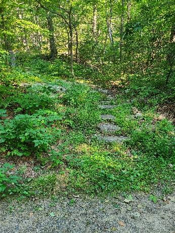
After traveling along the road for roughly ¾ mi, you will reach the intersection of Chatfield Road on your left and the start of the white/circle blazed trail with steps that lead to Split Rock on your right (photo of steps, above). Be sure to acknowledge this location as you walk past, you will return to it. Continue down the road for about 200 ft until you see an opening in the rock face on your right. This location is known as “The Quarry” by BRF staff and Cornwall locals.
The Quarry
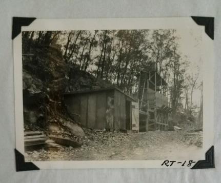
Located a few hundred feet southwest of Golden Rock, the remnants of an old quarry are seen along Sutherland Pond Road. This site was used in the 1930’s to gather material for an overhaul of the forest road and trail system. Large rocks were removed from the quarry and then placed into a crusher to be broken down and sorted to be used as the base for the forest road system in place today. This site offers a look into the geological history and composition throughout Black Rock Forest. (Left: picture of the quarry and stone crusher from 1937)
After visiting the quarry site, turn around and head back to the intersection of Chatfield Road and the start of the white/circle blazed trail. Golden Rock is located on your left past the top of the steps at the beginning of the white trail that leads up to the peak of Split Rock.
Golden Rock
Golden Rock – a piece of granite gneiss bedrock that bears the name of William T. Golden, visionary founder of Black Rock Forest Consortium who helped establish BRF as a field station – was dedicated to Mr. Golden on May 17, 2008. Additionally, this Ridge has been officially named Golden Ridge, approved by the U.S. Naming Board of the U.S. Geologic Survey. It is fitting that the Stillman Trail, named for the founder of the Forest itself – Ernest Stillman- runs the length of Golden Ridge connecting these two great men.
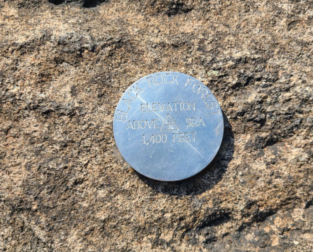
Continue up on the white/circle blazed trail for 0.35 mi to the peak of Split Rock. As you reach the top of Golden Ridge, take note of the large rock outcroppings that are spread along the ridgetop. Be sure to locate the survey monument at the peak of Split Rock. (photo right)
Split Rock & Sutherland Pond
At 1400 ft in elevation, the peak of Split Rock is a ledge overlooking Sutherland Pond. On a clear day the NYC skyline can be seen south to southwest. A perfect spot to pause for lunch. The view of Sutherland Pond, formed by a receding glacier, encompasses wetlands with water-lilies in bloom from May to September. Across the Pond, notice the darker green white pines emerge above the predominantly oak canopy. At 1246 ft, Sutherland Pond is the highest natural pond in the Hudson Highlands. It was used by Native Americans who frequented in the winter and fall seasons for food gathering – berries, nuts and meat.
After enjoying the views from Split Rock, take the yellow/square blazed trail northwest. Note: The yellow/square trail overlaps with the blue trail here, continue to follow the yellow/square blazes. You will pass an intersection of the “Short-cut” trail, yellow/triangle blazes on your left (do not take this turn) and the blue blazed Compartment Trail to your right. Continue on the yellow/square Stillman Trail until it intersects with the Sackett Trail.
Turn right on the Sackett Trail (yellow/circles) and head north for .35 mi, following the yellow/circle blazes until you reach the Mine Hill Trail. There will be a viewpoint shortly after turning onto the Sackett Trail with views to the west, a good spot to pause and take one last break before your descent. Make a left onto the Mine Hill Trail, yellow/diamond blazes, (follow the yellow Mine Hill sign) and head down to your vehicle. Take this last section slowly as your legs have gotten quite the workout within the past few hours!
Click here for a downloadable version of this trail guide.