The Hudson Highlands Wildlife Connectivity Project
Using animal behavior data to drive conservation actions
Dr. Scott LaPoint
Background:
Healthy, resilient ecosystems require successful, repeated movements of their organisms within and between their habitats. These movements allow organisms, whether plants, animals, or microbes, to find mates, food, or shelter, and provide ecosystem services such as seed dispersal. Unfortunately, landscape manipulations like habitat removal or barriers to movement like roadways, directly impede and threaten these vital movements. Reducing such threats is a worthy conservation goal. One way to achieve this goal is to facilitate landscape connectivity, a measure of how well a landscape facilitates movements, whether through movement barrier mitigation (e.g., wildlife crossing structures over/under roads) or by conserving landscape corridors.
Project purpose:
We at Black Rock Forest have worked for decades to document wildlife use (or underuse) of under-road tunnels and have worked with regional land preservation and conservation organizations to facilitate landscape corridors. We are now expanding our efforts by initiating the Hudson Highlands Wildlife Connectivity Project. Through this project, we will collect carnivore distribution and behavior data that will help us assess the landscape’s connectivity and to identify areas that are in need of mitigation (i.e., movement barriers) and those in need of conserving (i.e., movement corridors).
But why carnivores?
We have chosen to work with fishers (Pekania pennanti) and bobcats (Lynx rufus) Figure 1. But why?
Carnivores are worthy conservation targets due to their proportionally larger role in their ecosystem relative to their generally low densities. Meaning, they are typically uncommon, but carry large roles. For example, their presence affects behaviors and decisions of herbivores, which can influence forest regeneration and even tick prevalence.
Fishers are super cool, medium-sized (2 – 5 kg) carnivores native to the northern forests of North America. They are porcupine hunters, highly adept tree-climbers, and require intact forests for their survival. They are one of the most reintroduced carnivores in the world and require forested corridors to move between forest patches. After near extinction across the U.S., they have partially recovered in northeastern North America, yet remain threatened in the western U.S. At Black Rock Forest we have a unique opportunity to study this species at the leading edge of its recovery in New York.
Bobcats are equally fascinating, medium-sized (but larger: 8 – 13 kg) carnivores found throughout much of North America in a variety of habitats. They are one of the most studied carnivores in the world, yet remain elusive to most outdoor recreationists. Interestingly for our project, bobcats and fishers are competitors for space and food. The species are known to directly interact, typically with female fishers on the losing end, and we have hypothesized that the presence of bobcats could hinder fisher re-colonization.
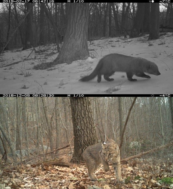
Figure 1: Fishers (top) seem rare in our study area, compared to the more common bobcat (bottom).
Where are we working?
Our focus is to understand whether our wildlife can move between the large forested spaces within our focus area. As a rule of thumb, we are working south of I-84, west of the Hudson River, north of Route 6, and east of Washingtonville, NY. That includes Schunnemunk Mountain and Storm King State Parks and of course Black Rock Forest. We are most interested however in where these animals go when they leave these protected areas, making the mixed landscape of private and public lands between them important for us.
* If you see a bobcat or fisher, alive or dead, inside our study area and have proof (e.g., picture, carcass, etc.), please contact Dr. Scott LaPoint (slapoint AT blackrockforest.org or 845-534-4517 ext 116) *
Our approach:
Our project consists of three major components and we envision a fourth if we secure sufficient funding.
Component 1: camera trapping
We are conducting a survey of the local carnivore population with camera traps. Camera traps are motion-activated tools that snap a picture whenever something warm passes in front of them. The purposes of the camera survey are to assess the carnivore community and to increase field effort efficiency during Component 2. The camera traps are attached to trees and baited to attract nearby carnivores. Camera trapping images are uploaded to emammal.org, a camera trap image service of the Smithsonian Institution. Here we store, manage, and share our images. The camera survey is done annually from October through March, across sixty sites within our study area.
Component 2: movement tracking
In January 2020 we began capturing and fitting bobcats and fishers with GPS-enabled tracking collars. Animals are handled and sedated at the site of capture to minimize stress while we assess the animal’s health and record some biological measurements (e.g., breathing and heart rate, temperature, body dimensions, etc.), assess sex and age, and collect ectoparasites. The GPS will record the animal’s location at 2 minute intervals. The collar also has an accelerometer that records the motion of the animal, allowing us to assess activity patterns, energy expenditure, and behavioral patterns. Bi-weekly we relocate our collared animals so that we can wirelessly download the data from their collars. All location and accelerometer data are stored online at movebank.org.
Component 3: connectivity modeling
There are several ways through which conservation biologists can assess and map landscape connectivity. We have found that spatial models that incorporate movement data collected for the target species within the landscape of interest is the best approach. Nonetheless, for robustness, we will estimate landscape connectivity with three complementary approaches. First, we will use the behaviors of the animals themselves (via the data their collars collect) to identify areas that facilitate corridor use.
The second approach estimates landscape connectivity by borrowing from electrical circuit theory. In this framework, features of the landscape are assigned conductance (or inversely, resistance) values, which are analogous to animal preferences for moving through particular landscape features. Circuit theory then predicts the flow of electricity across the landscape assuming that the animal has no knowledge of the landscape. The third approach, least-cost corridor models, is similar to circuit theory, except it assumes the animal has complete knowledge of the landscape.
Importantly, we will then validate the model predictions by placing our camera traps at predicted corridors and in habitat cores to objectively compare model predictions.
Results so far:
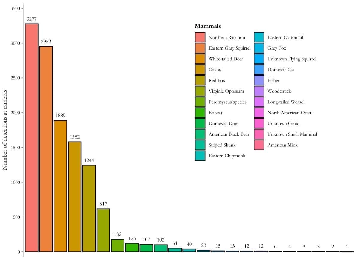
After two winter field seasons of camera trapping, we have collected >520,000 images of animals (Figure 2). We encourage everyone, especially other researchers and educators, to visit our study at emammal.org: The Black Rock Forest Carnivore Study. There you can access our data, see what we’ve found, and even see some of our favorite pictures.

Figure 2. After two winters of surveys, our cameras detected a variety of mammals, from raccoons to mink
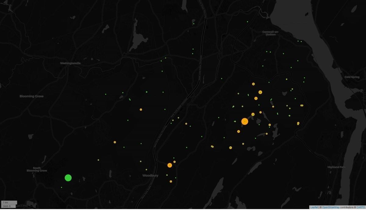
Our cameras have revealed an interesting spatial distribution of our two target species as well (Figure 3). Just with these data, we see hints that I-87 may impede fisher recovery into Black Rock Forest.
Figure 3: Distribution of fisher (green) and bobcat (orange) detection by cameras. Point size indicates frequency of detection, with smallest point size indicating camera location with zero detection.
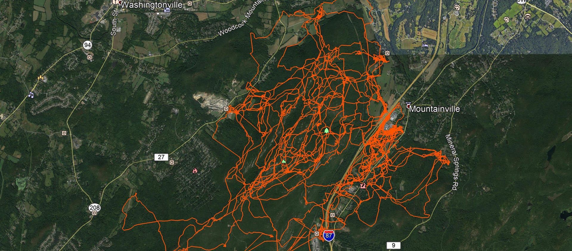
In February 2020, we captured and successfully collared a female bobcat. In 77 days, her collar has recorded >9,300 locations and > 37,000 accelerometer readings (so far!), revealing her activity patterns and movement preferences, including some road crossing locations.
We encourage all to go to the “Data” page on movebank.org, search for “Black Rock Forest”, and explore her data with us.
Updates:
We will update this page periodically. However, for weekly news and updates, please check Dr. LaPoint’s twitter feed (@sdlapoint) for updates on this project and others, plus some cool science news.
SUPPORT THE HUDSON HIGHLANDS WILDLIFE CONNECTIVY PROJECT
We welcome and encourage collaboration, so if you are a researcher and interested in doing so, please contact Dr. LaPoint directly.
We also have student and volunteer opportunities on occasion, so please reach out if interested.
More info:
For more information on the role of corridors, see conservationcorridor.org
For more information on road ecology and environmental issues related to roads, see environment.transportation.org
For an exemplary wildlife overpass project example, see the pronghorn overpass at Trapper’s Point
For more info on the work of Dr. Scott LaPoint, see his personal webpage or follow him on twitter (@sdlapoint).